As our friends and colleagues from flytechnologywho, by the way, helped to get this drone for testing, every wish from our defenders was taken into account by the company in the PROTECT+ firmware. And even now, active negotiations are underway to further improve the constantly updated software on this drone. And its positioning as something more than just the Enterprise series becomes clear even in a quick review. First, the drone itself has become larger and heavier (1604 grams) compared to its predecessor. But about everything in order.

Serious competitor
Autel, positions this drone as a direct competitor to the Dji M 30T, and indeed in terms of characteristics it is quite similar to it, although in size it is something in between the DJI M3t and the DJI M30T. But there is something that can completely distinguish this drone against the background of all competitors!
These are the frequencies at which it operates, namely 900 MHz/2.4 GHz/5.2 GHz/5.8 GHz. EVO Max 4T with PROTECT+ firmware uses advanced flight control modules and algorithms specifically designed to counter RFI, EMI and GPS spoofing. This allows the EVO Max 4T to confidently fly close to power lines, critical facilities and in difficult areas, such as combat zones. Special attention is also paid to the possibility of flying in no-fly zones — there are no restrictions on the drone. Advanced sensors allow you to see the security system at 720 degrees and move inside reinforced structures, underground or without GPS. Finally, manufacturers realized that there are zones on the planet without a GPS signal)).
As for spoofing, in the event of its occurrence, the drone automatically fixes a sharp change in coordinates and ceases to take into account signals from satellites. We can say full.

ATTI mode in the Autel drone is fully implemented, and it can also be activated directly from the flight software at any time. At the same time, as our tests have shown, the drone, unlike the DJI, does not begin to wear out in the wind thanks to the developed system of visual control of its own security cameras. And this, in turn, will mean a significant reduction in cases of loss of a drone due to the inability of inexperienced pilots to operate the drone in ATTI mode in strong winds.

The camera is a firebox!
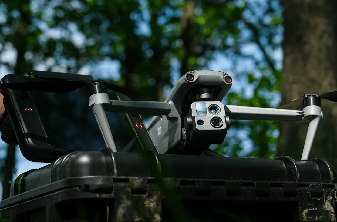
Separately, I would like to tell you about the camera, which turned out to be of surprisingly high quality. It includes a wide-angle camera, a zoom camera, a thermal imaging camera and a laser rangefinder for all needs. 8K 10x optical zoom in combination with software allows you to zoom in on images up to 160 krats. In terms of image quality at maximum zoom, the picture is similar to the Dji M30, but much higher quality. If the DJI m 30 camera has 12 MP, Autel can boast already 50 MP, visually the difference is not very noticeable, but 50 MP makes it possible to see more small details at a considerable distance, and this is often very necessary.
No miracle happened with the thermal camera — it's all the same 640x512 with 16x zoom. The only thing we paid attention to is that when enlarged, the thermal imaging image does not significantly lose in quality. It is also possible to manually set the range of temperatures that are of interest during the search, and this is very appropriate in our work)). But what really impressed is the progressive night vision mode of the main camera. Even in absolute darkness, it is able to raise the ISO value as much as possible, which makes it possible to navigate in space without problems.

As for the laser rangefinder, it is standard in its characteristics, and the maximum range is about 1200 m. It is also capable of displaying coordinates in the WGS84 system. Our team was pleasantly surprised when they saw the artificial intelligence work of this drone. In addition to various techniques, it is able to distinguish between people, and quite well it can distinguish between military and civilian.

Flights and flights
Another advantage of this drone is the system of visual route construction and security cameras installed on board. The system is able to build complex routes when returning home, noticing the slightest obstacles on its way, easily bypassing them. But the important thing here is not even that, but what about its direct competitor the DJI M 30?

The security system is built on the basis of stereo infrared sensors arranged from all sides, while they are very clearly visible in the PNB. While the EVO Max 4T is responsible for safety with spherical cameras with a viewing angle of 120°, and in combination with the night mode of flight “Stealth”, in which all the lights on the drone are extinguished, it allows it to remain more invisible.
You can write a separate article about the software, but in short, then everything is very concise, ergonomic, and appropriate. To begin with, this is the first drone that has officially received localization on the territory of our country and is ready to communicate with you in your native nightingale language). It seems like a trifle, but still nice)). In addition, drones that will be delivered to the territory of European countries will have a choice of English or Chinese. But it was not without translation incidents.
For example, the Sport mode, in the Ukrainian version for some reason was translated as “Unreal” mode, and on the one hand, this only encourages you to try it, and on the other hand, you want to think twice when you see such a warning: “The maximum speed in the mode is unrealistic 23 m/s, the software can turn off”.

In addition, we all know that on DJI drones software absolutely cannot be updated, to prevent unpleasant surprises on the battlefield, there is a completely opposite situation, since with each new release new chips are opened and new opportunities appear. For example, at first the drone shot only in 4K quality, and now after the update your drone will be able to do it in 8K. This means that the potential built into it at the plant will be revealed gradually. It is also worth noting that data covering user and drone information, including flight logs, location, and account information, can only be physically accessed locally via the drone.
Seriously, most likely this is just to remove responsibility, since the software is still at the writing stage and is constantly updated, opening
Encrypted Data Storage: Supports AES-256 encryption for photos, videos and flight logs and is password protected.

Convenient management
The menu of the new software is intuitive and, by analogy with DJI, is arranged in a convenient list. Among the features I would like to note the ability to disable GPS right during the flight.
Separately, you can turn on or off the landing lights, which is definitely useful for those who are engaged in delivery. Also near the landing lights there is a threaded connection, which can help securely fix any fastening.


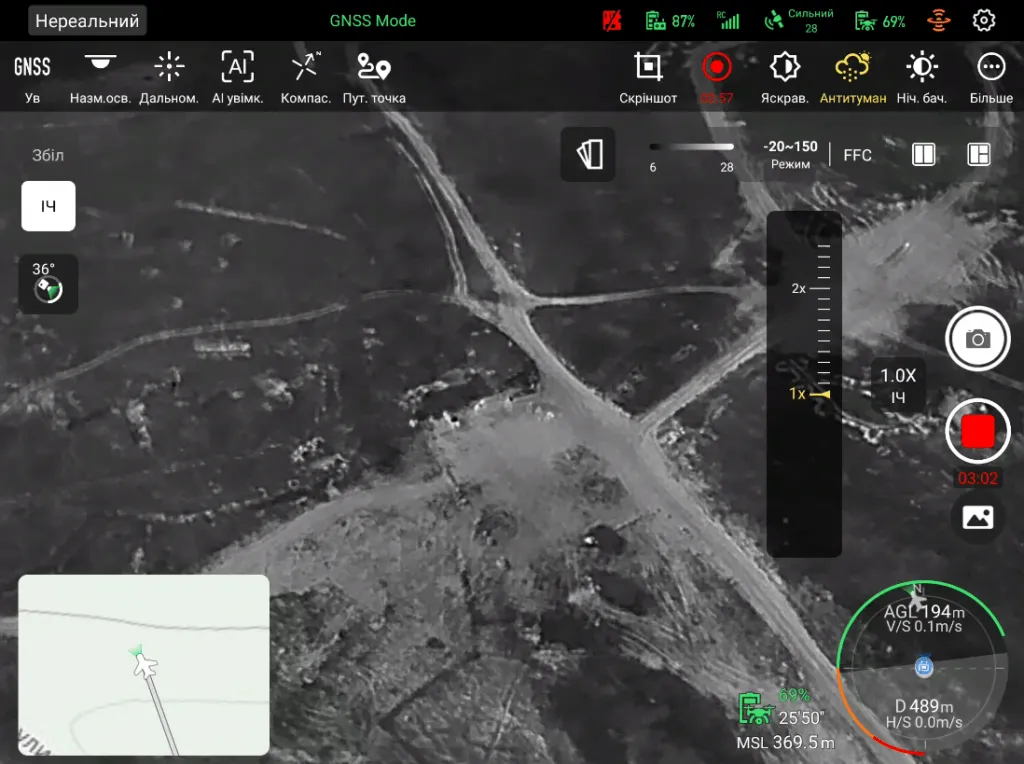
It is also enough just to take a screenshot of the screen and start recording it, which is mandatory during a combat flight. Now this is done by the program itself. The “Anti-fog” function allows you to make the picture more contrasting and better to shoot in rain or fog. But camera settings are only available when the drone is on the ground and during flight all you can fix is exposure. Also, there is no possibility to choose the formats and size of the image being taken. By default, it always remains maximum.
It is worth mentioning also such an important point as the downloaded map of Ukraine which is very detailed. And due to the screen distribution function, you can simultaneously use both the card and the thermal imager.

A little more “goodies”
Autonomous path finding on this drone is thanks to Autel's Autonomy Engine. It collects environmental data and plans three-dimensional flight trajectories through complex environments such as mountains, forests, and buildings. Uses include rapid 3D scene reconstruction, public safety surveillance, industrial control, and topographic photography. And this means that such a drone can be sent on automatic missions, since if the GPS signal is lost, it will be guided by the visual.
In addition, in the future it is planned to implement the A-Mesh system, which provides autonomous communication, connection and joint operation of drones. Several nearby drones can act as relay points, which greatly increases efficiency and in case of loss of communication with one of the drones, it will automatically transmit its signal through a drone flying nearby. This, in turn, will allow to implement two ambitious ideas at once. First, it will be more difficult to lose a drone under the action of an enemy REB if several drones are sent to the task at the same time, since they are all capable of catching automatically at frequencies of 900 MHz/2.4 GHz/5.2 GHz/5.8 GHz, and secondly, even if control of one of the drones is lost, it will be able to switch to transmitting its signal through the drone of a partner and move away to a safe distance. The use of such tactics will significantly affect the advance of our military into enemy territory and will help in planning offensive operations.

About Ease of Control
When it comes to driving, as always, driving Autel is soft and pleasant. Maximum flight speed: 82 km/h. The drone reacts very accurately to the sticks and in principle the control is similar to its predecessors. The only thing that we thought was strange was the speed of rotation. With fairly small dimensions, the radius of a sharp turn in the standard mode is about 12-15 meters. But all this can be changed programmatically in the settings of the remote control.


When it comes to launching it by hand, as you probably know, Autel drones do not like it very much.
In this model, there is no such problem at all. And it is possible to take off and put it on his hand. In flight, it behaves quite predictably and stably. A
The declared flight time of 42 minutes. allows you to stay in the air for a long time on one departure and work on target. As for the height, as in all hotels, it is standard 800 m vertically, which in principle is more than enough for this drone. Nevertheless, it became possible to turn off the height restriction and raise the copter at least 2000 m. However, the manufacturer claims that EVO Max 4T is capable of climbing 7 km with a maximum flight range of 8000-20000 m.
Summary
So, in summary, we can safely call this drone a successful attempt to do something much more than the Enterprise series. This is a huge step forward, and a pretty serious application for the title of military drone. We are sure that this drone will definitely find its application on the battlefield, and its main application can be correction and reconnaissance, and in some cases, its carrying capacity will be enough for the delivery of gifts)).
Basic information
Climbing speed, km/h: 28,8
Descent speed, km/h: 21.6
Maximum speed, km/h: 82.8
Maximum height, m: 7000
Max. permissible wind speed, km/h: 43.2
Load capacity, kg: 0,399
Ambient temperature, degrees: -20+50
Flight time, min: 42
Equipments
Thermal imager: yes
Cam
Matrix: 1/2 “CMOS
Lens: Focal length: 11.8-43.3mm (35mm, equivalent: 64-234mm) Aperture: f/2.8-f/4.8
Camera rotation: yes
Sensitivity, ISO: video 100-6400 (auto), photo 100-6400 (auto)
Video recording capacity, dots (frequency, k/s): 7680×4320
Photo resolution, dots: 8000×6000
Stabilization: yes
Camera suspension: 3x-axial
Control type, number of channels: Remote Control (Smart Controller V3)
Built-in display (diagonal), inch: 7.9
Remote power: 5800 mAh
Maximum range of remote control, m: 8000-20000
Aircraft
Spare blades, pcs: 6
Blade protection: no
Other: Spare control knobs (pair), Power cable, Memory card 32 GB, Case, Remote control - 1 pc, Strap
Dimensions and weight of the aircraft
Width, cm:57,6
Length, cm: 66
Height, cm: 14,9
Weight, kg: 1,600
Color: gray